 San Diego Gas & Electric (SDG&E)
San Diego and Orange Counties, California
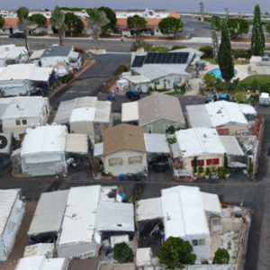 With the use of fixed-wing aircraft and drones (UAV), GIS Surveyors produced several 2-D planimetric drawings for nine different mobile home park locations throughout San Diego and Orange County. The project was a pilot upgrade program from SDG&E that would upgrade the existing electrical and natural infrastructure on each site. This would not only update the infrastructure, but also make each site compliant with future regulation within their jurisdiction. The project required GIS Surveyors to mobilize the aerial work for each mobile home park site by establishing aerial control and flight plans.
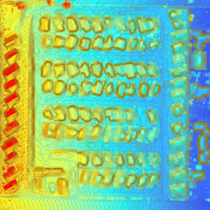 While this task was taking place, other members of the GIS Surveyors team performed boundary calculations and organized a utility sweep of the sites. Once all the information was collected (aerial / drone photos, boundary, and utility), our team consolidated this information into one drawing per site, after a thorough QA/QC process. Due to GIS Surveyors’ firm understanding of boundary and utility mapping / surveying, our team were able to deliver an expedited product to SDG&E without compromising the integrity of the final product nor the information they received.
Key Components
- Base-mapping
- Utility mapping / surveying
- Fixed-wing aerial photogrammetry
- Drone aerial photogrammetry
- Construction staking
- As-built surveying
- Land services support